
 An estimated 52 metric tons (115,000 pounds) of derelict fishing gear collects on the shallow coral reefs and shores of the Northwestern Hawaiian Islands every year. Since 1996, our marine debris team has removed 848 metric tons (1.87 million pounds) of derelict fishing nets and debris from these remote islands and atolls protected by the Papahānaumokuāea Marine National Monument. This year, we aim to remove an additional 30–50 metric tons.
We are executing this important mission in three stages:
- Leg 1: aboard the NOAA Ship Oscar Elton Sette for 24 days,
- Leg 2: on the shores of Midway Atoll for 14 days, and
- Leg 3: aboard the charter vessel Imua for 18 days.
From Above
Our mission begins on September 19, when the NOAA Ship Oscar Elton Sette departs Honolulu for the Northwestern Hawaiian Islands. At our first location, for the first time, we will deploy a small unmanned aerial system to photograph and detect debris from above at Pearl and Hermes Atoll. If this aerial photography is effective for locating derelict fishing nets and gear, we can use it to survey high-density reef areas.
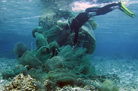
From Underwater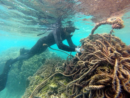
Our team includes specialized NOAA divers, who tow underwater behind a small boat to survey the vast reef area and free-dive to carefully cut and remove derelict nets from reefs. When we remove derelict fishing nets, we transport them on 17-foot inflatable boats to the Sette. The ship cannot carry back all of the debris that accumulates annually in the Northwestern Hawaiian Islands, but we will use this opportunity to remove as much as possible and study the impact of debris on reefs. Once the ship reaches capacity, the team will attach six satellite tags to track selected nets and study their trajectories from wind, wave, or storm activity over time.
The Sette will carry the collected fishing gear and nets back to Honolulu for processing—but first, she will drop us off at Midway Atoll, where we disembark. At Midway, we will clean marine debris from the waters of the barrier reef and the shores of three sandy islands.
From 3-D Images
This mission is about more than just debris removal. Past marine debris teams have observed derelict fishing gear smothering and breaking coral colonies on a large scale, but have no data to support their observations. This year, we will measure the ecological impact of debris using a new technology called photogrammetry (structure from motion). Using cameras, we can create a three-dimensional model of reefs entangled with nets, and use this model to measure coral die-off and re-survey coral growth or other changes to the reef after we have removed the derelict fishing gear. 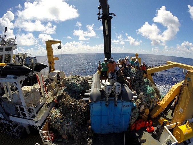
From Land
After Midway Atoll, the team will board the Imua, bound for Kure Atoll, Pearl and Hermes Atoll, Lisianski Island, Laysan Island, and French Frigate Shoals. We have been measuring and removing shoreline debris at these islands for several years. The team will continue to survey and remove entanglement hazards and shoreline plastics. Once we transport all the marine debris to Honolulu, Schnitzer Steel and Covanta Energy Corp will process and incinerate it to generate electricity for Oahu’s homes in the Hawaii Nets to Energy Program.
NOAA Fisheries marine debris project in the Pacific Islands region is supported by NOAA (Pacific Islands Fisheries Science Center, Pacific Islands Regional Office, Marine Debris Program, and the Damage Assessment Remediation and Restoration Program) in partnership with the University of Hawaii’s Joint Institute for Marine and Atmospheric Research, National Fish and Wildlife Foundation, U.S. Fish and Wildlife Service, Midway Atoll National Wildlife Refuge, the State of Hawaii’s Department of Land and Natural Resources, and the Papahānaumokuākea Marine National Monument.