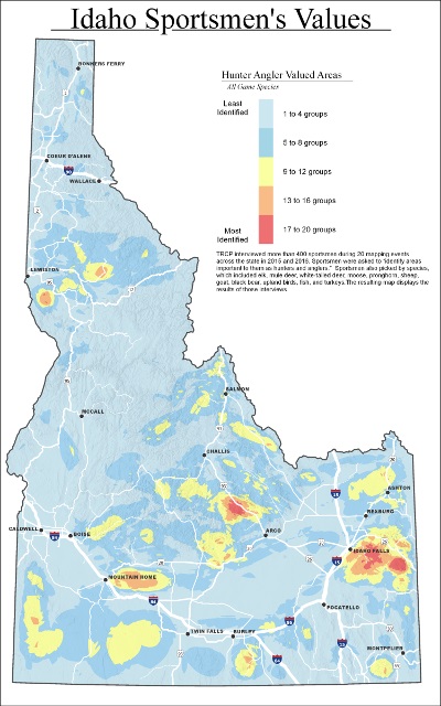
 Maps of Idaho’s most valued hunting and fishing areas have been made available to state and federal agencies to help guide future land management decisions. More than 400 hunters and anglers contributed to the Theodore Roosevelt Conservation Partnership’s mapping project, and the data have been assembled in a geographic information system (GIS) that can be overlaid with maps showing critical habitat, land ownership, and planned development.
How Is Your State Protecting and Promoting
It’s Valuable Resources For Sportsmen?
After hosting 20 mapping events with sporting clubs from around the Gem State, the TRCP confirmed that hunters are fiercely protective of nearby hunting and fishing opportunities and are profoundly aware of the areas with the most waterfowl, fish, upland birds, predators, and big game.
“With the help of sportsmen, we’ve been able to pinpoint lands that are cherished for their hunting and fishing values, so that land managers can prioritize habitat conservation and the enhancement of public access in these areas,” says Rob Thornberry, TRCP’s Idaho field representative out of Idaho Falls.
The Idaho results showed a sporting community that is loyal to public lands near home, with most residents picking favorite hunting and fishing areas within three hours of their front doors. “There was great fidelity to the public lands in our own backyards,” Thornberry says. “At the same time, roughly a third of sportsmen and women from all 20 mapping events said they still travel all over the state to pursue game and fish.”
Sportsmen were interviewed in Idaho Falls, Pocatello, Salmon, Stanley, Boise, Twin Falls, Moscow, and Coeur d’Alene. The resulting maps will provide important and previously unavailable data to state and federal agencies to help:
- Balance other land uses with the needs of fish, wildlife, hunters, and anglers
- Identify areas where public access needs to be maintained or improved
- Identify key high-use areas warranting special conservation strategies
- Justify actions and funding requests aimed at conserving highly valued wildlife habitat and hunting and fishing areas
“This map will serve as a useful tool for conservation and management as state and federal agencies evaluate areas for habitat improvements and hunting and fishing opportunities,” says Mark Gamblin, regional supervisor for Idaho Fish and Game in the Pocatello region.
“Knowing Idaho’s population is increasing by 20,000 to 30,000 each year, sportsmen and women need to consider this growth to ensure that wildlife and quality habitat remain abundant,” says Brian Brooks, the executive director of the Idaho Wildlife Federation. “This map highlights, quite literally, where we should focus our efforts.”
The first mapping project of its kind was launched by the TRCP in 2007. Maps have also been completed for Montana, Wyoming, and Arizona.
