
 On the previous update (7 January) K33 (and likely the rest of K pod) had arrived in the northern Strait of Georgia. They headed back south later that day and traveled through the San Juan Islands the night of the 8th. By the evening of the 9th they were at the west entrance to the Strait of Juan de Fuca and spent most of the 10th near Swiftsure Bank before heading south down the Washington coast that evening. They continued south on the 11th and by the morning of the 12th were nearing Cape Disappointment near the mouth of the Columbia River.
.

7 January – The previous update (4 January) found K33 (and presumably the rest of K pod) at the western entrance of the Strait of Juan de Fuca. On the evening of the 4th the whales headed east into the Strait of Juan De Fuca and by the afternoon of the 5th were headed up Haro Strait (with J pod based on the calls on the San Juan Island hydrophones). They spent the 6th in the southern Strait of Georgia and by this morning they were in the northern Strait of Georgia, an area that we have previously seen J pod to commonly frequent

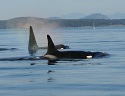
4 January – We are continuing the satellite tagging project that we began in 2011 to help us understand where Southern Resident killer whales go in the winter, and thus their winter habitat use. Last Thursday afternoon, 31 December, we deployed a satellite-linked transmitter on an adult male, K33, in central Puget Sound. The location data transmitted from this, and the previous tags we have deployed, tag will be key for NOAA Fisheries in our efforts to address the data gap in winter distribution identified in the Recovery Plan as well as provide information for the designation Critical Habitat in coastal waters. This project is a collaborative effort between the NWFSC, Cascadia Research Collective, and the University of Alaska, with supplemental funding provided by the U.S. Navy.
In 2013 we gained our first detailed look at the coastal movements and habitat use of Southern Resident killer whales with the tag deployed on K25 (see 2013 blog). In 2015 we obtained another 3 months of location data from a tag deployed on L84 (see 2015 blog), which showed movements and habitat use similar to those exhibited by K pod in 2013. Understanding the full degree of this whale community’s movements and habitat use is important to informing the winter data gap and Critical Habitat designation needs. As such, with the expected development of a major El Nino in the North Pacific Ocean this winter, the location data obtained from the tag attached to K33 could provide important insights into how the whales’ respond to the impacts this perturbation may have on their prey. We may deploy additional tags later this year to assess their movements compared to the early winter movement data we obtained previously because little is still known about where the whales go during the spring months (April-June).
The tag deployed on K33 is similar to the tags previously deployed on J26, J27, K25, L88, and L87. In response to an attachment failure of the tag deployed on K25 in 2013 (resulting in retention of an orphaned dart in the fin of K25 which we documented to have been lost sometime this past year) and as required by our research permit, we assessed the cause of the failure and worked with the tag manufacturer on a modification to mitigate for this possibility. The redesign incorporates a petal at the base of each dart to put more drag on the dart in the event of transmitter loss, which will reduce the time the dart remains in the fin.
The tag was deployed on K33 as K pod was traveling north out of Puget Sound on 31 December, 2015. By the Friday, 1 January, the whales had arrived at the west entrance to the Strait of Juan de Fuca. They have remained in the area between the entrance to the Strait and Swiftsure Bank since then. An interesting aspect of them remaining in this area for the past several days may have to do with our observation that the K14 matriline was not with the rest of K pod during our encounter. However, on Saturday, the Center for Whale Research encountered J pod, with the K 14s, as they headed south in Haro Strait and then west toward the entrance to the Strait of Juan de Fuca – likely to rejoin with K pod.
We will post updated information and maps on this page for the duration of the tag deployment. For more information about the Satellite Tagging Project, see our FAQs.
