
 By Michigan State University. Ask any fishermen where they catch largemouth bass, and they will tell you “in the weeds”. These weeds, also known as aquatic vegetation, often hold greater concentrations of largemouth bass and other fishes. The really good fishermen will even be able to tell you what types of vegetation they think the bass like – perhaps bulrushes, lily pads, coontail or cattails. Fish researchers might really just be fishermen with fancy boats and special tools trying to verify their hunches (hypotheses) using the scientific method.
Part 1 of this Michigan State University Extension article series introduced Joe Nohner, a doctoral student in the Michigan State University Department of Fisheries and Wildlife and discussed the relationship between shoreline vegetation, edge habitats and fish utilization of the microhabitats created by natural shorelines. Part 2 provides additional insights into Nohner’s ongoing fieldwork investigating the importance of aquatic vegetation to largemouth bass populations.
Which kinds of vegetation do largemouth bass prefer? Do these preferences simply influence where the bass are distributed, or do they also influence the survival and growth of largemouth bass? Nohner set out to test these questions during the summer and fall of 2014 by surveying the largemouth bass populations in 16 Michigan lakes.
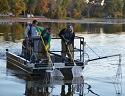
Fish were captured at multiple sites on each lake through the use of electrofishing to collect data on fish distributions and abundances (video of an electrofishing survey can be found on Nohner’s website). Nohner’s crew recorded the length and weight of each largemouth bass, along with GPS coordinates to document its location on the lake. To determine the age of the fish, the crew collected scale samples. After stomachs were pumped to collect their gut contents and determine what the fish were eating, the majority of fish were released.
The next step was to map the vegetation, coarse woody habitat, and docks in each lake. Nohner boated around each lake and mapped shallow aquatic vegetation with a GPS. The GPS data were then converted to maps such as the one below. Each map color represents a different type of vegetation, with the light blue representing “vegetation absent”. Overlaid on the map are the locations of Largemouth Bass collected during electrofishing surveys.
Continue reading this article at this LINK.…
—–
Join ODU Magazine on Facebook here at this LINK…..
Join ODU Magazine on our Twitter fishing site here at this LINK…..
Join ODU Magazine on our Twitter hunting site here at this LINK…..
.